All pre-1500 portolans share some grossly distorted, obviously lesser-known areas, such as the north beyond the channel and the south of the Syrte. The oldest, the Pisane and Cortona, have the north of the Black Sea unknown and the Adriatic badly tilted. This could be the result of errors in compilation of atlas pages and some missing pages.
There are already indications that a possible source atlas was not sectioned into geographical basins like today's nautical charts. The next option would be a cut along a geographic grid, along latitude parallels and longitude lines.
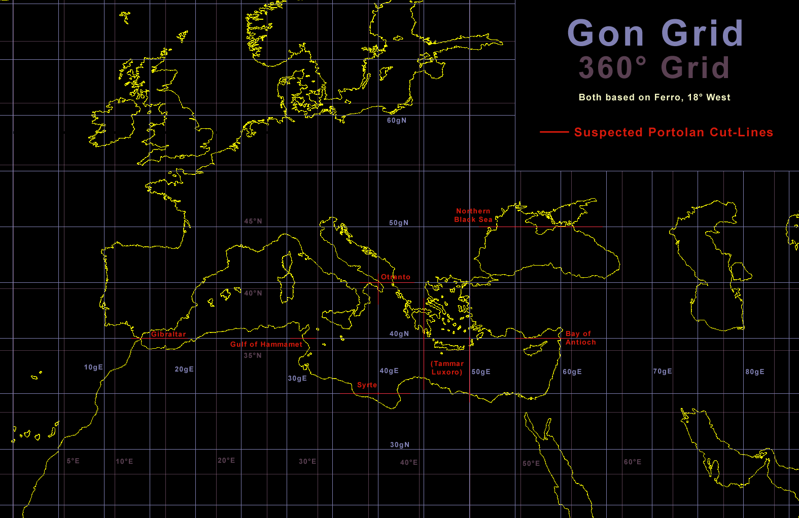
The reference points of any probable grid are the equator for latitude and the island of Ferro (18° W of Greenwich) for longitude. We know that both were used that way in classical and modern times. As Pujades (2007) pointed out, judging from the scale bars the creator of the portolan data preferred a modern-like decimal system in 5 and 10 units. So the grid would be divided in 5 or 10 steps.
The Gon system was introduced together with the Meter by France in the late 18th century. It is a fully decimal system and divides a circle in 400 units. So each quadrant has 100 units and one unit is equal to 0.9°. The units were first called "grad(e)" but later "gon" (greek: gonia, angle) to avoid confusion. It allows faster calculation for precision geodetic surveying and is still used in Europe for that purpose.
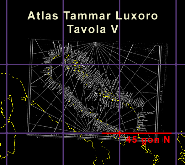
Searching for a cut grid we found that the 45° or 50 gon latitude was the cut line to the unfit area for the basic setup done some weeks before. The position of the southern Crimean peninsular has a good accuracy (ca. 25 km) to the more distant opposite coast. But the area above had an error of up to 220 km and extreme deformations. So this cut line around 50 gon North is clearly visible.
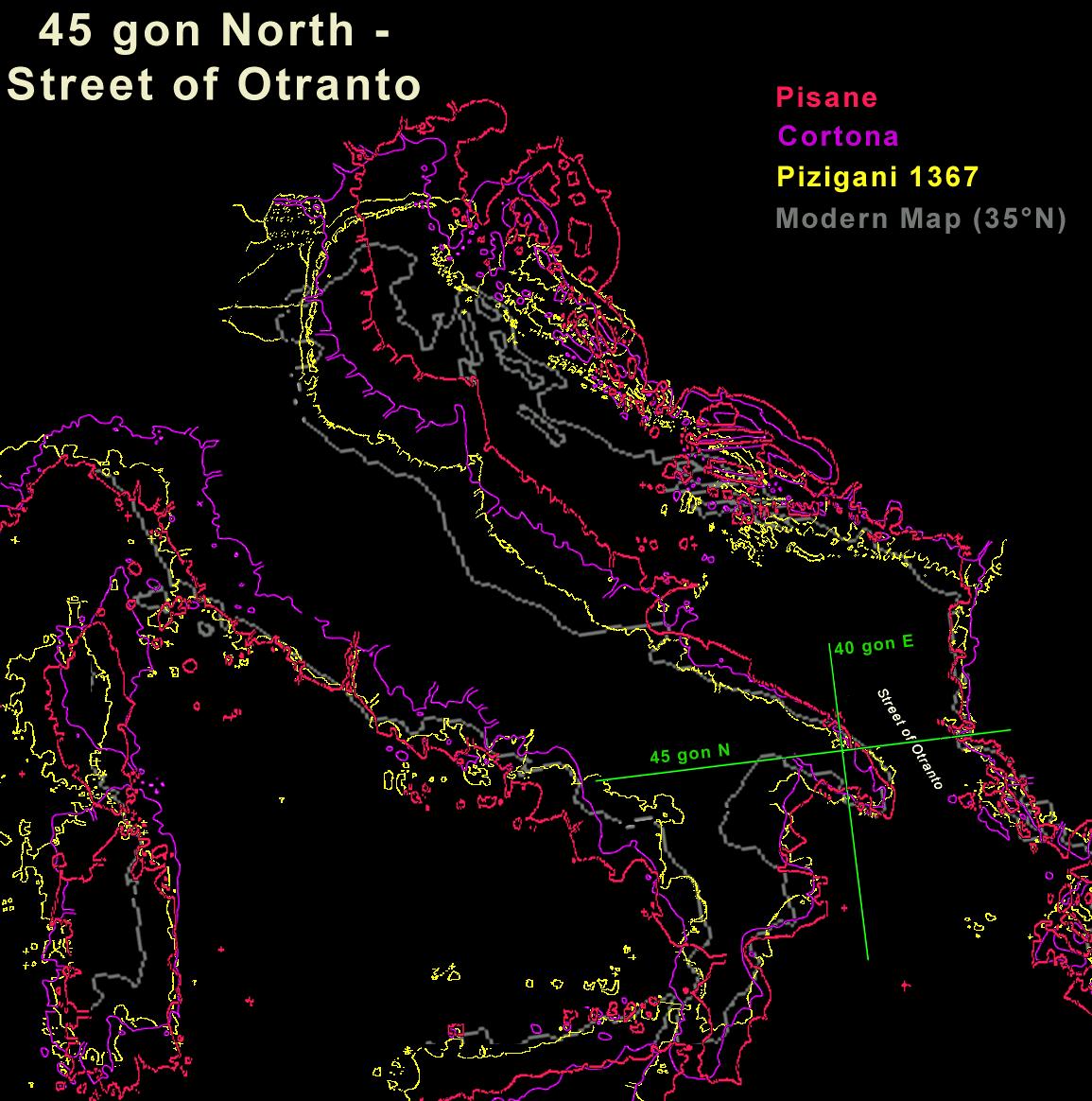
One is close to the crossing of the 45 gon parallel (latitude line) with the 40 gon East meridian. The other at the opposite side of the strait at the 45 gon parallel again. Just by chance this parallel cuts the coastline at each side where the real coastline makes some change in direction too. A map cut here needs a considerable overlap to get the parts correctly aligned again. It was not enough for the drawers of the Pisana and Cortona.
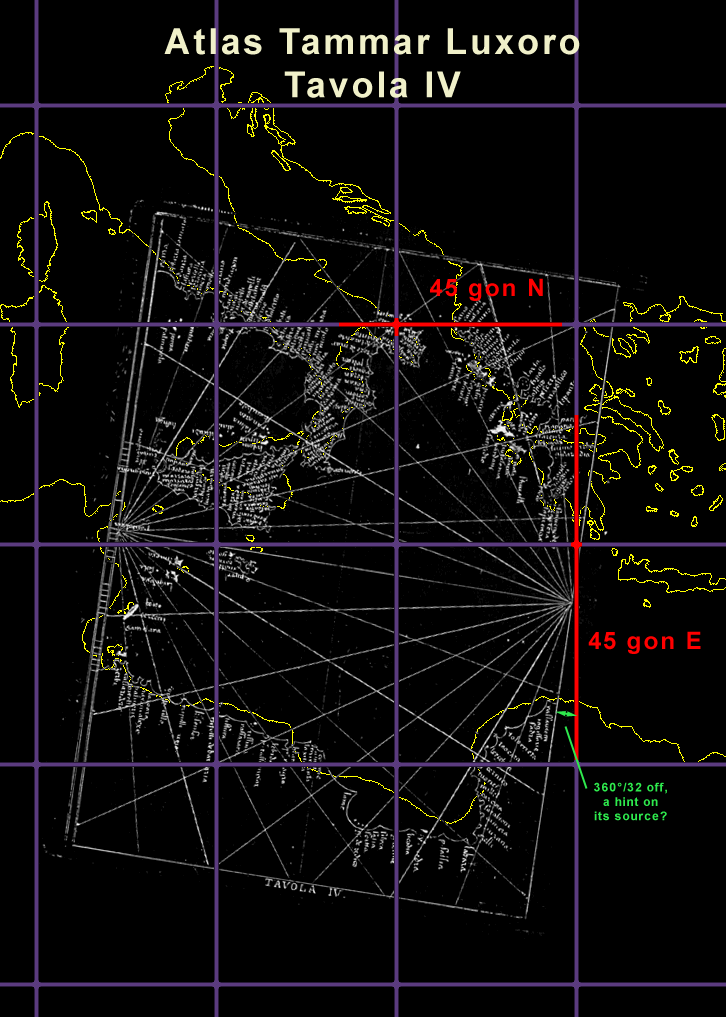
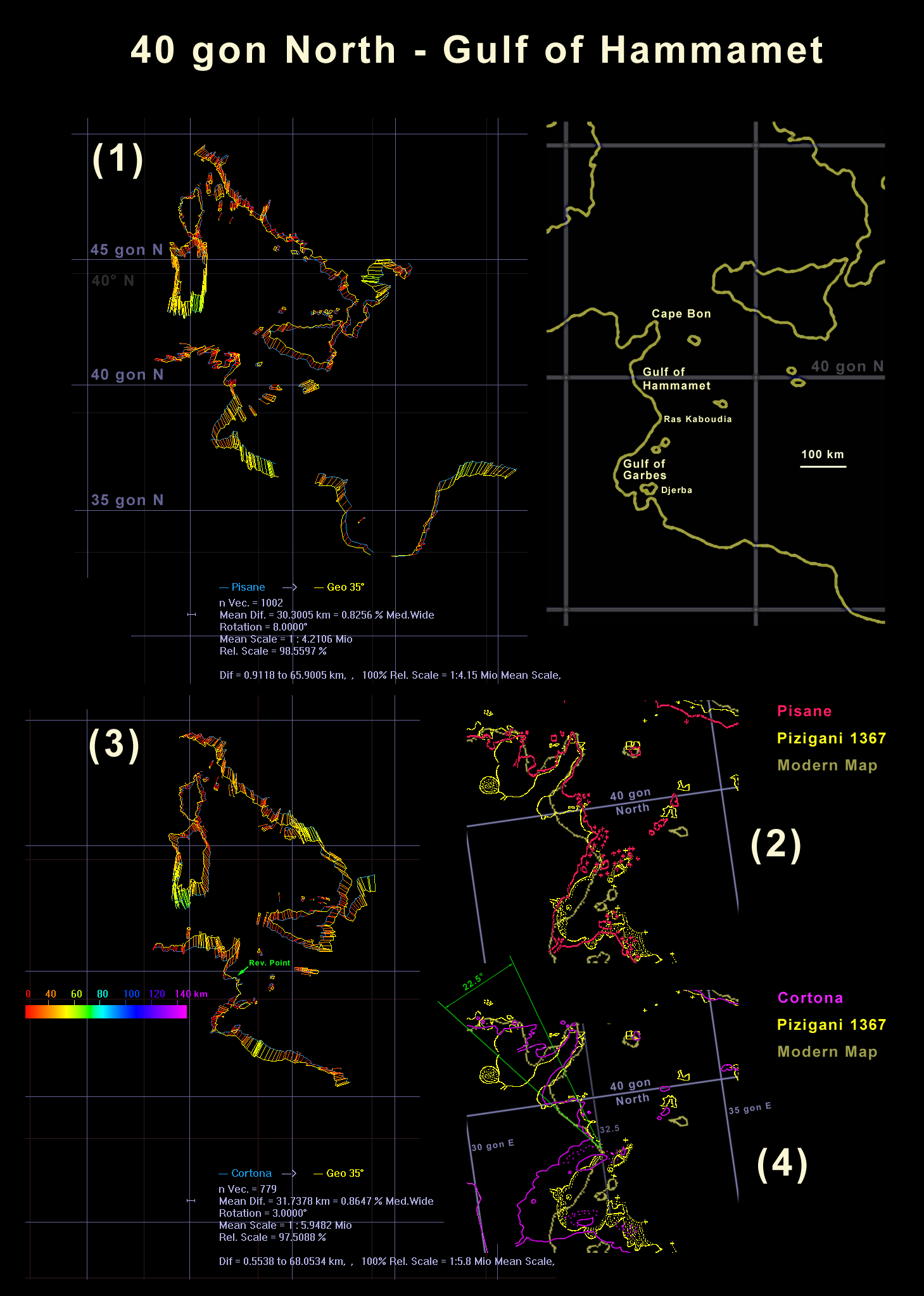
Luxury atlases like those made by Vesconte show much overlap. But cheap ones like the Tammar Luxoro do not. Here the Adriatic sheet is cut straight around 45 gon North. So the drawer of the Tammar Luxoro made less effort to improve his source but simply copied at least some sheets of it. It shows that the portolan source atlas had almost no overlap.(2) A detail comparison with a modern map reveals too short a distance on the Pisane from the Gulf to the next cape, Ras Kaboudia. But much more interesting here is the Pizigani chart of 1367 that was used as background reference.
It has a coastline exactly at the 40 gon North latitude but perpendicular to the real coastline in this Gulf. In the Cortona chart the very same error occurred. This could not be by chance. In both cases the chart drawer mistook the 40 gon line in his source atlas for a coastline.
(3) The Cortona shows here a reverse or revolving point ("Rev. Point") of the difference vector. It goes down to zero and almost reversed its direction for the whole south below the Gulf. It reveals that the area near such points could offer a fruitful detail investigation.
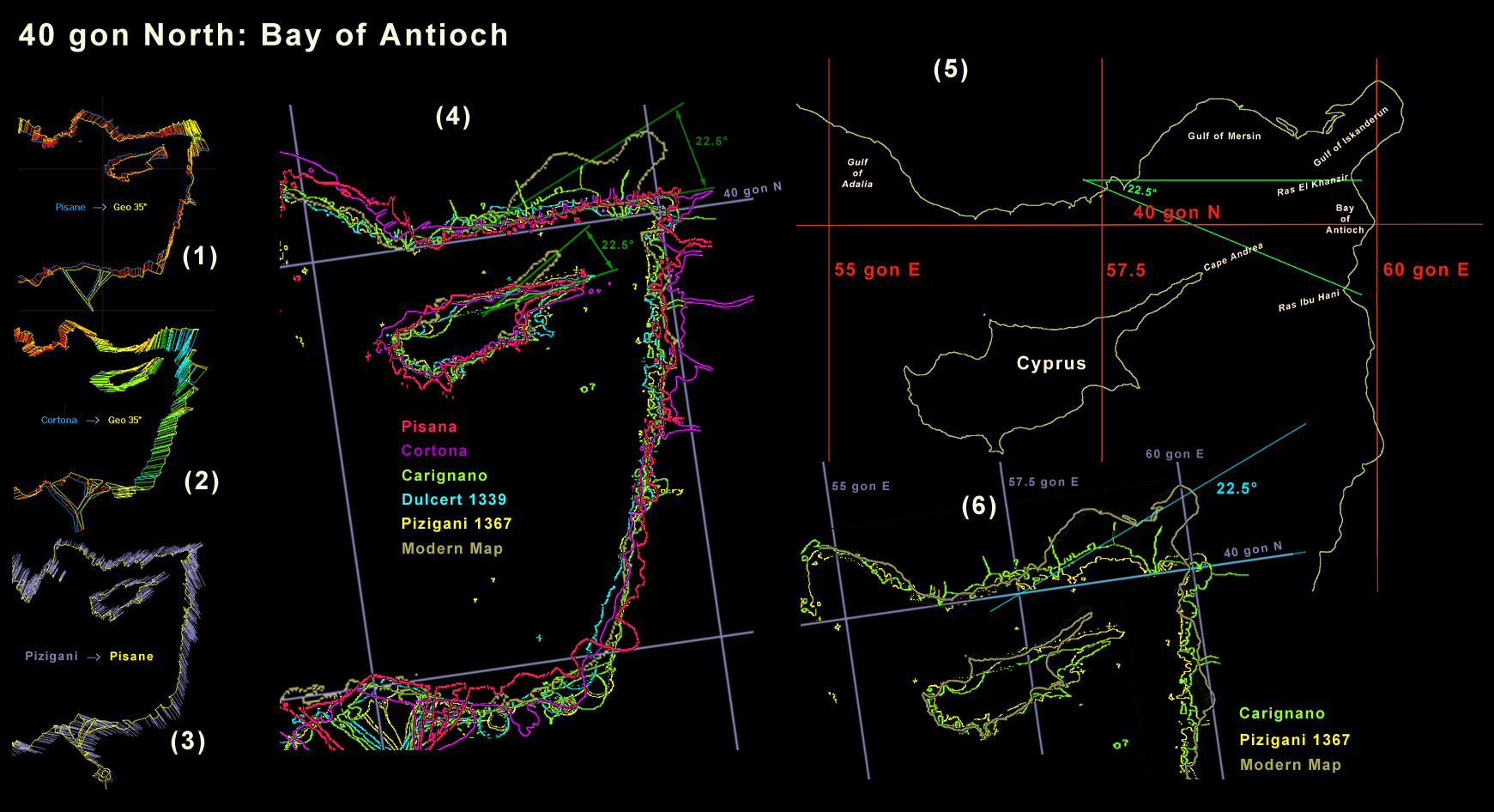
(4) The Pizigani and the Cortona both have a rotation of ca. 22.5° of the coastline below the Gulf. For the Pizigani the point of rotation is almost exactly at the middle meridian of the 30 to 35 gon map. I looks like it is by chance but probably it is not, as the Bay of Antioch suggests.
(3) The Pisane fit to the 1367 Pizigani chart shows no rotation but a sudden direction change in the difference vector at the Gulf of Iskanderun. So it was a compilation error of several (all ?) portolans but most severe in the Pisane.
(4) An overlay by several portolans shows about the same mistake. The northeastern coastline and the northeast of Cyprus is tilted by around a 16th of a circle, 22.5°. The Pisane and Cortona show the Bay of Antioch well, but not the Gulf of Mersin that most others do, like the Carignano as the best example. Probably the source of the Pisane and Cortona already had the Gulf of Mersin missing or not distinctive enough.
(5) A modern high resolution map of the area. It gives a hint why the portolans had a local rotation of ca. 22.5°. The coastline point of rotation is around the 57.5 gon center meridian of the 55 to 60 gon map. From this point two capes at the east, Ras El Khanzir and Ras Ibu Hani, were ca. 22.5° separated. Further, on a suspected source map of low resolution, the immediate coastlines around both capes have the same directions and may look very similar. So a compiler could believe he sees an overlap between two maps.
The "strange" finger of Cyprus and the 22.5° tilt from the Gulf of Mersin to Iskanderun would then change to a more normal, more straight geographical picture too. This line of argument only makes sense if the source atlas sometimes required a rotation of 22.5° of course. But after the Gulf of Hammamet this is the second time that such a 22.5° rotation at the center meridian of a 5 gon wide map happened.
(6) As a result of the 22.5° rotation the Ceyhan delta coastline now directly matched the 40th gon parallel -- a further reason for the compiler to get the coastline straight and an indication that this parallel was somehow present in the source atlas.
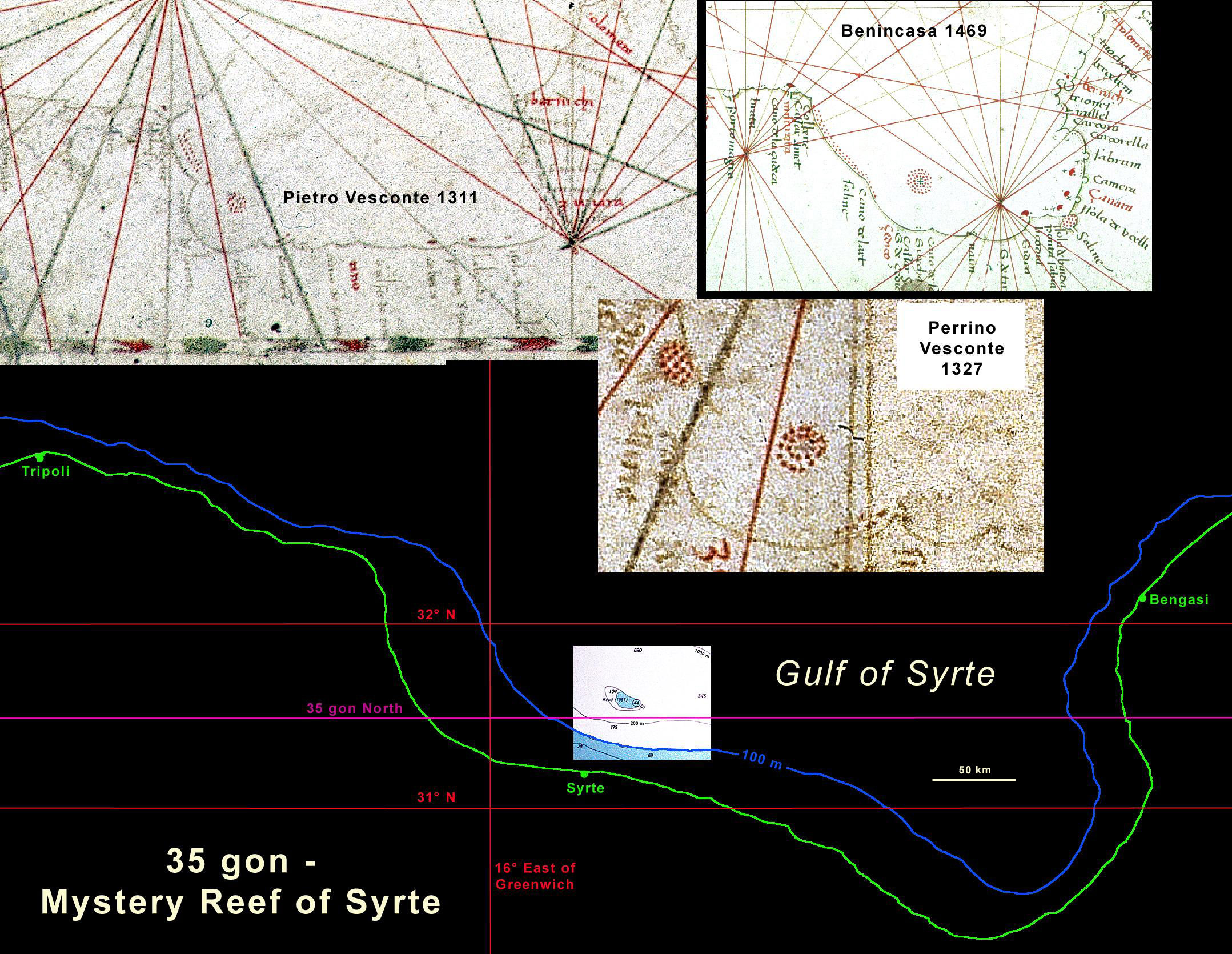
We can locate the cut line of their knowledge quite precisely. It is below 31° 35´ N, the latitude of Syrte reef and above 31° 10´ N were the next downward bow begins. That fits very well the 35 gon line of 31.5° N.
The Syrte reef is the most interesting geographical detail feature of the portolans. All have it. Some only as a disc of dots for dangerous shallow banks. others with a cross at the center, a sign for a dangerous reef. The cross is already in the early charts of 1311 and 1327 but difficult to see.
The mystery is, there is no Syrte reef today. About 43 km NNE of Syrte City is a small 50 m deep plateau of 5 km diameter. Its peak is 44 m below sea level. Even for the largest ships today, that is no reef at all. Looking from a medieval sail crossing the Gulf it is unlikely that someone would notice this rather small plateau. So how could this plateau appear in a medieval chart?
The only explanation I have is a local tectonic sink. The limited bathymetric data suggests it could be the top of an old undersea volcano. If its magma chamber cools out it will lose pressure and the topography around it will sink. Similar sites are known in the Mediterranean from Roman times but none up to 40 meters difference in sea level. Nevertheless it is not impossible that it was 40 m up even 1000 years ago. Classification and dating of coral remains offer a unique chance to get a possible date of the portolan survey.
Most of the anomalies mentioned above are common to all portolans. If all portolans were based on the compilation of a 5 x 5 gon grid atlas, that should result in further common characteristics. Some of the above anomalies were caused by wrong or unclear features in the atlas. The features of this atlas may have caused further compilation errors not recognizable by the naked eye.
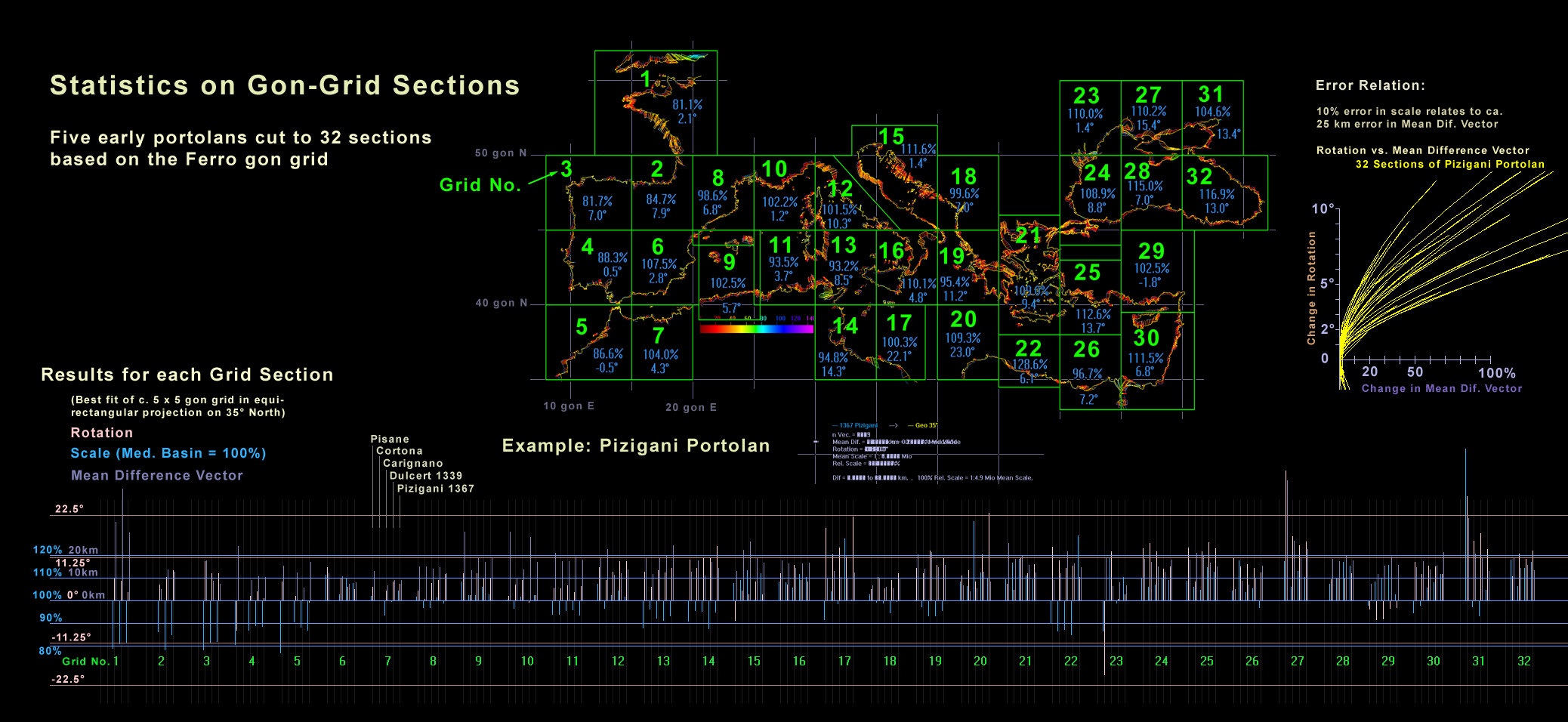
But it may come up in a cartometric analysis. Compared to a modern map one would expect the atlas maps of somewhat similar rotation, scale and average error. To check this, 5 vectorized portolans were cut into 32 maps of (mostly) 5 x 5 gon.[1] The graphic below presents the cut on the Pizigani chart and the results for each grid section for all 5 portolans.
It shows a fair to good similarity for each grid map and a good correlation for all 32. In other words, the specific aberrations (scale, rotation, mean error) of each grid map is not confined to one portolan but found in most. This is no proof but a good statistical support that the above gon map atlas is hidden in all or most portolans.[2]
The above statistic shows a tendency for scale increase from West to East. This could be caused by an unexpected type of projection. Another explanation are different editions of the source atlas. From the Pisane we know that at least one version without Atlantic existed.
The most dramatic low scale values in the Mediterranean have grid sections No. 11, 13 and 14. As already found by Wagner and Steger, the southern coast of Sardinia is to close to the African coast. Grid sections 11 and 13 cut the upper third of Sardinia at 45 gon North. If the atlas maps 11 and 13 at Sardinia had some overextension to the other maps, that would explain this scale anomaly.
The compiler not aware of the overextension would fit it to the coastline end of the other map. That way a small part of the Sardinia coast would be in the final chart twice. In the above analysis that grid sections would show a larger geographic area and therefore a smaller scale. As we see in case of the Pizigani sections 11 and 13 had 93.5 and 93.2 % scale only. If one looks above under §2.6, Gulf of Hammamet, the same type of mistake could have caused the smaller scale in section 13.
From the previous analysis we can reach the following points:
For a normal atlas this makes no sense. A single chart would be the best and easiest way to preserve the portolan data. The atlas makes only sense if it was intended to hide the data. To keep it secret and only usable for those initiated. The atlas would be designed to keep secret the distance and directions between ports.
The final hint is the 22.5° error northeast of Cyprus. The compiler of all portolan charts from the atlas expected a 22.5° tilt between map sections as a common feature of the atlas. So this must be a central element of the atlas design.
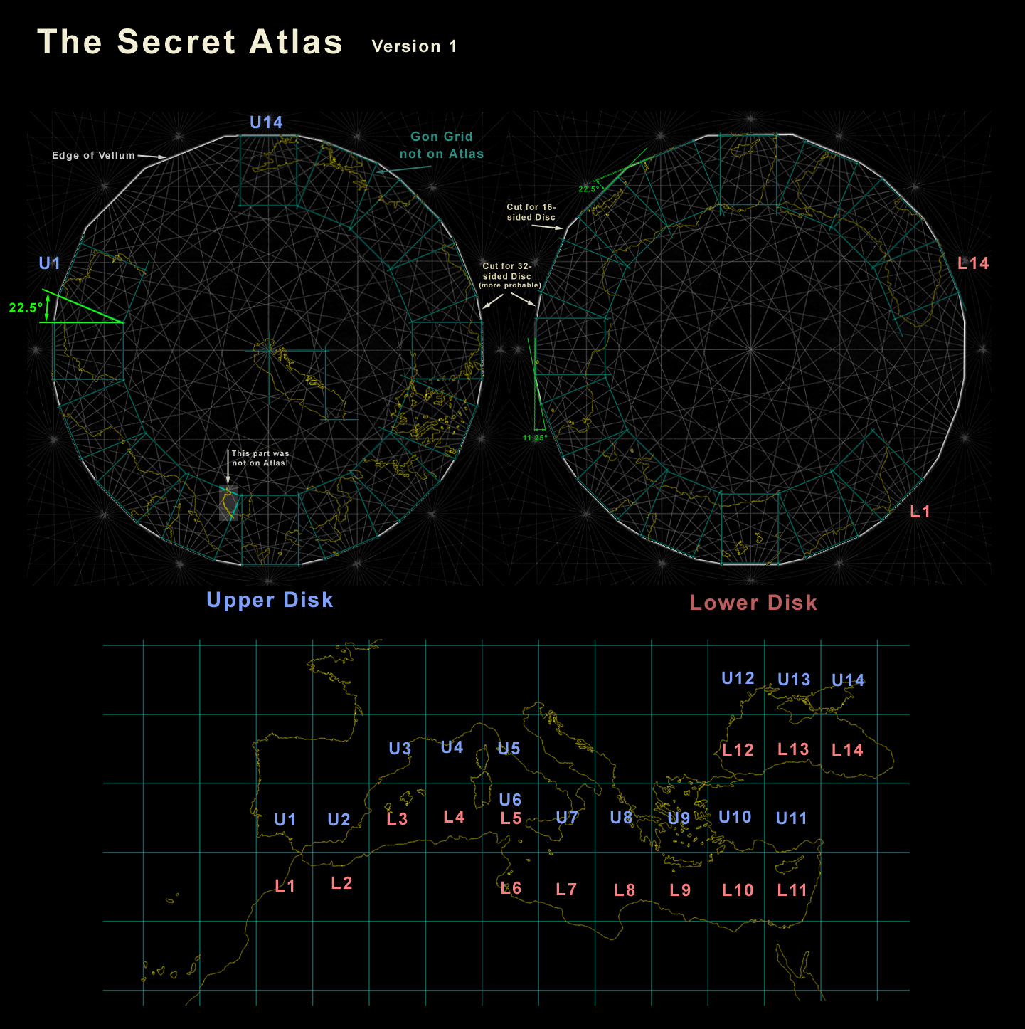
The result of all this points to a atlas of small maps that were drawn inside a 16 "winds" rhumb net. Probably each map was a 5 x 5 gon grid. It would be possible to place the content of the Carte Pisane on one single rhumb net that way. But it may probably need the use of two slightly different scales.
A better way would be to place it on two rhumb nets, the vellum of each net cut at the outer latitude line of the maps. So one would have two discs. The maps could be sorted so that one disc contains the upper (northern) map and the other disc the lower (southern) map. Both discs placed together would then create a 5 gon wide and 10 gon high map.
The graphic here shows how such a two disc atlas may have looked like. A modern map was used and the gon grid placed with the coastlines. But the real atlas had no drawn gon grid, only coastlines. Otherwise those 22.5° errors would not have happened. Here the maps were placed on the net in an easy to use way, like from a rolled up chart. But to enhance secrecy they could be scrambled over the net in a random way and encoded with letters from a code word or sentence.It is interesting that the two disc solution still has enough space for the Atlantic coast maps, too. So the compiler of the Pisana either had a single disc or a redacted two disc version for Mediterranean traffic only.
Besides the 40 gon parallel at the Gulf of Hammamet above - I know of no evidence that the gon grid lines were drawn on the atlas. The meridians would stand out because they cannot fit the rhumb net. That would endanger the concept of secrecy. But the cut coastlines like we see in my graphic above could still raise the same problem. It could be avoided if the end of the gon meridians were used for a further vellum edge cut line, like shown in the graphic for most of the disc. That gives the option to place fake coastlines in the area between the real maps. It may further give a way to explain the mistakes in some local coastline tilt of 22.5° or the 11.25° (= 360°/32) most but not all of the atlas Tammar Luxoro is tilted.