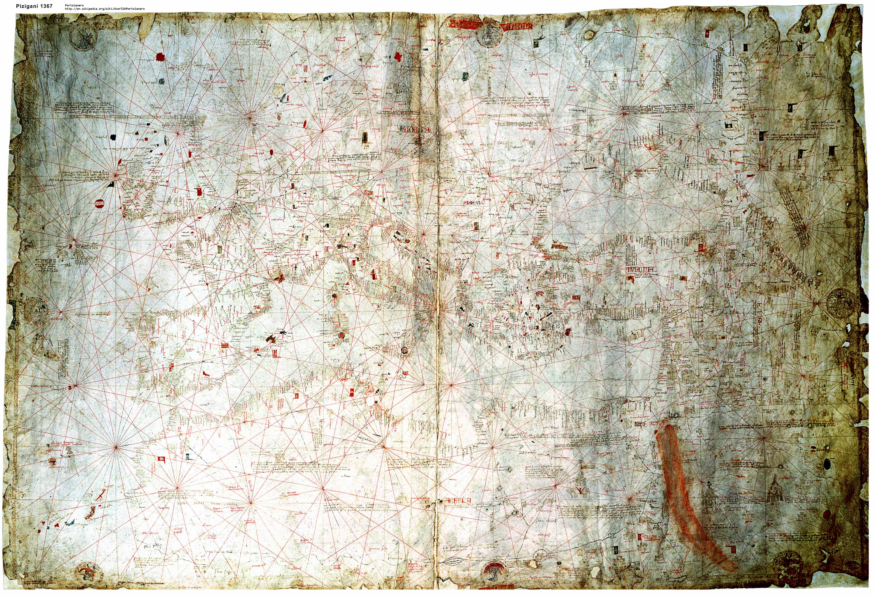
The Pizigani portolan chart of 1367 in a computer enhanced image of reduced resolution (1 MB). (Full 10 MB Version)
The AD 1367 Pizigani (Pizzigano) Italian portolan chart was drawn in Venice and is today in Parma (BR ms. Parm.1612). It is
The chart size is according to the literature
The scale of the Mediterranean basin is about 1 : 4.9 million. According to Pujades (2007) who created the most complete collection of early portolans it is the largest chart before 1400.[1] No one has yet taken measurements of the circle radians to determine any shrink of the parchment.
It can be found as "ms. Parmese 1612" at the Biblioteca Palatina of Parma, Italy. The date of acquisition and the history before is not mentioned in the used literature. In 1913 Stevenson described the chart as "remarkably well preserved."[2]
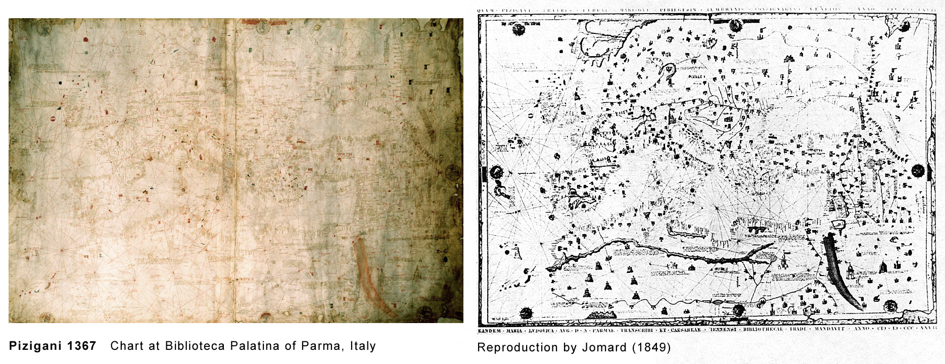
Only a few older portolans are in better condition. The chart is today broken into two parts but by a supporting back cover kept in correct position close together. Any information loss here is unlikely and the Jomard reproduction of 1849 shows no tears.
At Jomard the outer edge was intact with only few losses. Today the edge has several losses usually some cm long and typically up to 2 cm deep. But at the northern edge where Jomard has small losses it is today up to 6 cm deep. It seems some of the area lost was marked grey by Jomard. That may indicate a fungus problem which could spread rapidly but which is very controllable today. Due to that parchment loss from the time of Jomard there was some textual loss, too. But compared to the text volume of the whole chart it is very minor.
There seems to be no important loss of information inside the map. In an area where the ink seems faded out this is mainly a contrast and resolution issue of the photographic reproduction technique. To capture the whole map even professional equipment reaches the technical limit. For coastline or text details a close-up is still the only possible way.
The first known copy was made in 1827 as a present for Maria Luisa, daughter of the Austrian Emperor and widow of Napoleon Bonaparte. It is in the Nationalbibliothek of Wien, Austria.[3]
The most important reproduction was the black and white hand lithography by Jomard in 1849.[4]Edmé François Jomard (1777-1862) was a leading French engineer, archaeologist and cartographer. The high scientific standards known for his edition of the "Description de L'Egypte" he applied for these reproductions, too. By comparison with close-up photographs, Jomard's reproduction of the 1367 chart and of the Carte Pisane seem very accurate. All text and graphics are very visible. It was used for cartometry. All reproductions of the 20th century were of much inferior quality and almost useless for scientific purposes.
The best modern photographic publication is on the recent DVD by Pujades of 2007. It gives a very good impression of the whole chart's general look but it has no export function and is not of sufficient resolution for all detailed investigations.
The image I uploaded for Wikipedia is the most detailed one published so far. It is from a professional chemical large format camera. But even this equipment was not able to produce an image in the necessary adequate contrast and resolution. It was scanned and image processed to reveal the most detail. Compared to the original the contrast is enhanced and the colors are darker. Therefore for details and cartometry the edition of Jomard is still unchallenged.
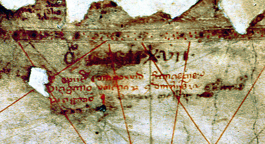
Fischer reported an observation by the Parma librarian Odorici in 1866 that Domnus may stand for Dominus, meaning "Priest" and the next word may be "(Ge)rardus" pizigano.[6]
Fischer further mentioned a very interesting observation by Desimoni in 1877. He read "Dominicus" and suggested that Francesco Pizigano was the son of Domenico Pizigano who was already dead in 1367. Desimoni pointed to a map of the Holy Land of 1350 by Marino Sanudo preserved in the BNF Paris. In the legend of this map Marino Sanudo is named and a Dominicus Pizigano. It is interpreted that Dominicus Pizigano was the artist of Sanudo who was already dead for several years in 1350.[7]
A Pizigani link to Marino Sanudo is important. Sanudo is suspected to be the key person in the creation of the first portolan chartmaker school. It was there in Venice by the Vesconte family where the first dated portolan was produced in 1311. Sanudo's main effort was to promote a new crusade to the Holy Land. The Cortona chart, besides the Carte Pisane usually suspected to be the only pre 1311 portolan, belonged to an unknown group with the very same intent.[8]
Because all researchers so far used only their eyes and the ink degraded by time, these older readings had some value. The problem calls for modern equipment. But the problem is not only readability. Besides the 1367 chart they only produced an atlas in 1373 which was not geographically related with the chart.[9]
The atlas has this authorship inscription:
From this poor spelling and grammar evolved the opinion that the 1367 chart was drawn by the brothers Domenico (and/or Marco?)[10] Pizigano and Francesco Pizigano. As plural of Pizigano it is usually called the Pizigani chart.
For reasons not mentioned[11] Pujades, a paleographer, used Pizzigano instead of Pizigano. This inevitably draws a link to another chart of 1424 signed "Zuane Pizzigano".[12] According to Pujades, it is assumed as probable that Zuane was the son of one of the two aforementioned.[13] This 1424 chart is much better known to the broad public because it has two large islands, one called "Antilia", in the Atlantic east of the Azores. The leading Portuguese historian Armando Cortesao saw it as "intended to represent the easternmost part of the American hemisphere" and it may indicate a discovery of America before Columbus.[14] According to Pujades, the 1424 map is the oldest extant "medieval Atlantic partial chart"[15] and was the first time the island Antilia was on a map,[16] but followed soon by other portolans. As we see below, other historians saw the whole Antilia problem already raised by the Pizigani chart of 1367.
Pujades, a palaeographer, considered the Piziganis' writing of "limited technical training" and "the lettering of both works [of 1367 and 1373] ... is characteristic of people in the habit of writing though not of true professionals experienced in copying books or documents in good calligraphy." The "exaggeratedly high degree of spelling variations when it came to writing place names" suggests they had no training as cartographers either. They were probably not of a high cultural level.[17]
Their authorship inscriptions of "both works reveal that they knew very little Latin grammar and orthography." But the many topographical legends on the 1367 chart were in so much better Latin that he is sure they copied it from somewhere. Pujades noted on the 1367 chart, after writing the names in black ink, they forgot the name of Valencia on the red run.[18]
Nordenskioeld noted: "It is perfectly impossible to decide the age of portolanos by their style, for even the hand-writing is slavishly copied."[19]
If the Pizigani brothers really copied the hand writing it may give a paleographic link to the author of the source map. But there is another link. The Latin of the map legends used abbreviated wording as known from books where writing space is limited.
The abbreviations changed by time and cultural milieu. The source writer was an educated trained clerk in an office of a government or government-like organisation and cleared for secret high level documents. He was active sometime in the 1180 to 1265 timeframe. There were not many people like him and the number of extant documents from this time is limited. There could be other documents by his hand or the abbreviation scheme may point to his educational or operational peers.
The Pizigani brothers chart of 1367 was the first Venetian portolan after the last Vesconte production in 1327.[20]
It is ornamented in the Catalan style. But the Pizigani brothers were Venetians and the atlas six years later is typically Italian.[21]
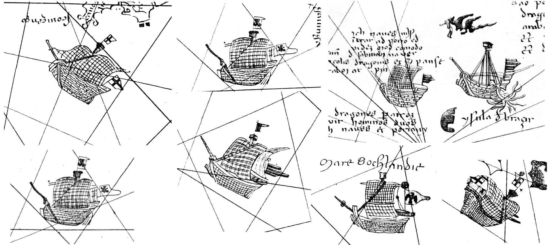
It is the first chart that introduces the representations of ships.[22]The chart had the Nile send one arm to the west in the Atlantic. This was based on classical sources and was Arab opinion since Masudi of 10th century.[23]
It is the first mention of the Hoggar or Ahaggar mountains ("Uggar") in the central Sahara.[24]
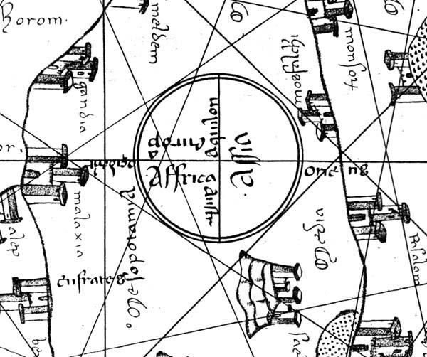
Pujades noted a 3 cm diameter "diagrammatic circular mappamundi", a mini schematic world map north of Damascus. Such a sketch map one "would hardly have seen anywhere other than in the Latin bookish milieu."[25]Already Lelewel in 1852 noted the similarity of the legends of the Pizigani 1367 chart with the Atlas Catalan of 1375 and suggested a common source.[26]
Pujades suspected a dependence on Dulcert's[27] 1339 portolan. Some decoration[28] and the explanatory legends are similar but more were on the 1367 chart.[29]
The poor Latin the Piziganis used in their authorship inscriptions makes it impossible that they created these additional legends.[30]
Instead they simply copied it. The source they used was a map from with later copies were the source for Dulcert.[31]
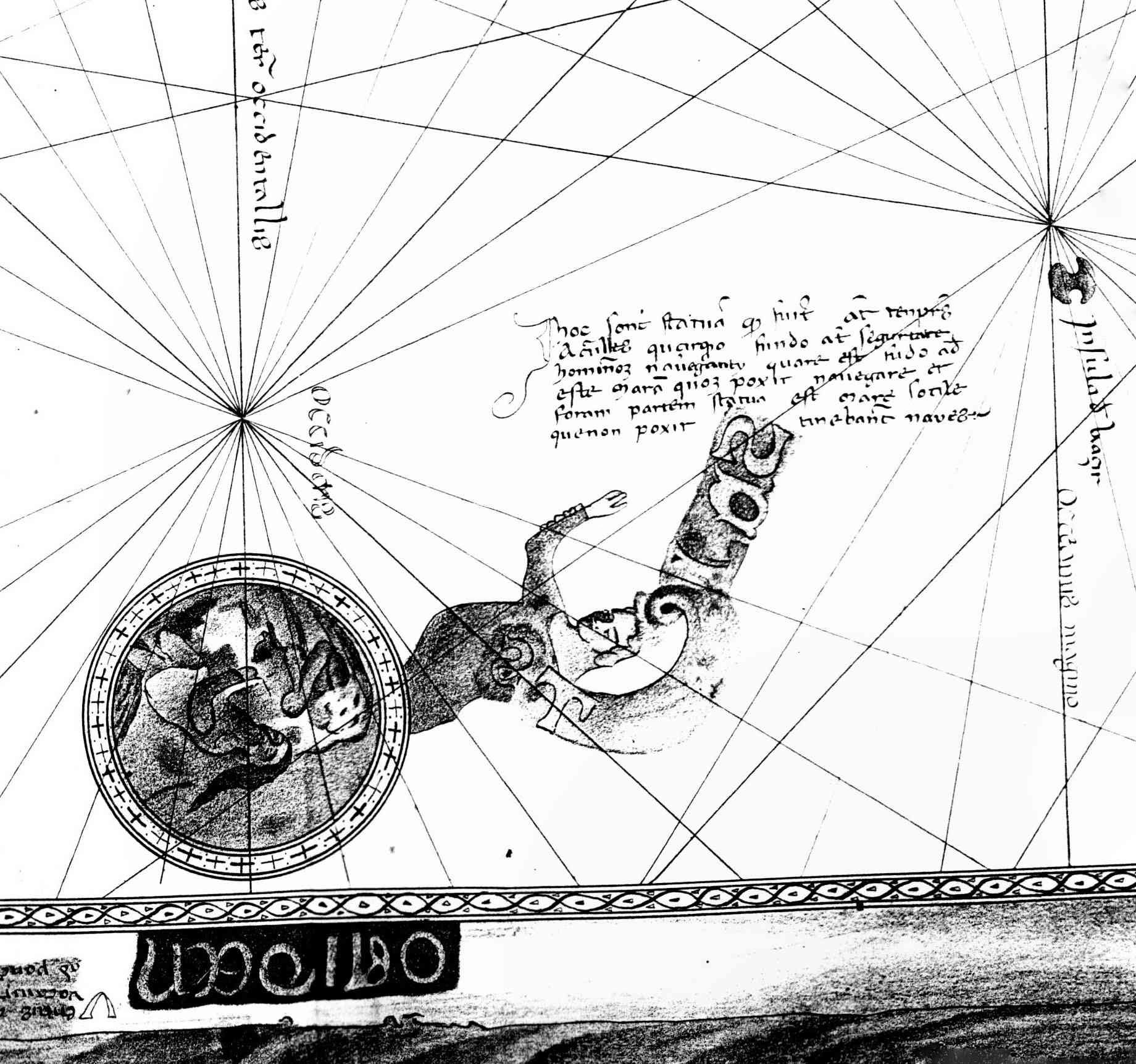
He came to the conclusion that the inscription tells about columns that were from the temple of Hercules: the sea is safe until here but beyond these statues sailors cannot navigate.
Most others, since Buache in 1806[33] read something like Antilia instead of Hercules. In 1977 Kare Prytz was able to have it photographed with the assistance of a Mr. Odd Wibe of the Norwegian embassy in Rome. Prytz, in his famous and important book on Vinland[34] came to the conclusion of Antilia, too.[35]
Hennig's work makes other relevant points,[36] but he wrote that he and his supporting paleographer were only able to use a reproduction.[37]
So the question whether this chart is the first mention of "Antilia" should still be open. Because it is not a simple matter of reading it should be investigated by modern means.[38]
Some attention should be devoted to the "strange" (Hennig) figure close by, pointing to this inscription. It is without parallel on portolans and somewhat reminiscent of medieval book decorations. It has some letters in the ornament and probably a message still to discover.
The most pointed opinion on the chart was by Heinrich Winter. After reviewing the early portolans on topographical and descriptional details, he concluded:
Campbell (1987) mentioned Winter's conclusion and called Winter an authority.[40] Indeed there is supporting evidence below that the coastline of this chart had some features that stand out from all others.
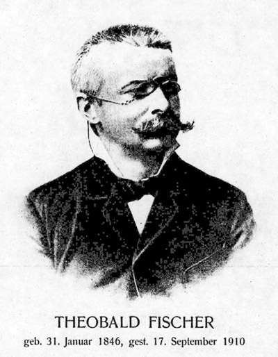
The famous German geographer Theobald Fischer (1846-1910) supported the edition and wrote a commentary supplement in German.[42] It was considered of such importance that it was reprinted in the Netherlands in 1961.
So by focusing on the inaccurate features Fischer (1886) came to the same conclusion of a common source as Nordenskioeld (1889). But in contrast, Nordenskioeld focused on the remarkably accurate coastlines.
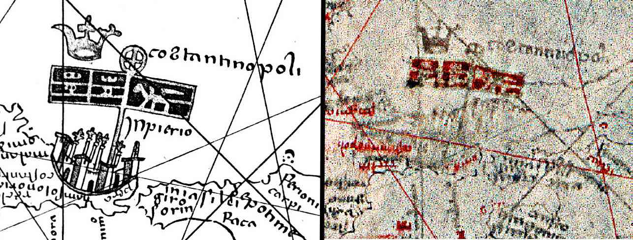
This Latin Empire had its own flag different from the invasion forces. Therefore the crusaders and Venetian flag at Constantinople may indicate a time closer to the invasion date in 1204. In a journal article Fischer too argued that the date was probably soon after 1204.[44]
Fischer argued that it was unthinkable for the Piziganis as Venetian cartographers to place a Venetian flag over Constantionple given that by 1367, the Genoese had long been the supreme power there.[45]
Fischers discovery makes the portolan charts almost 100 years older than usually thought. This finding is still known in German literature[46] but never mentioned or even discussed in English language publications. This text may be the first time. As one authority suspected, it may let the bottom fall out from most portolan research. But on a second look it is somewhat less dramatic:
Fischer's precursor to the Pizigani chart has so far only been given informal descriptions. Due to its importance in portolan research it is necessary to name it. Here it is suggested to use the name "Conqueror Map", because it shows the conquest of Constantinople and was most likely made by western Christians.[47]
Fischer mentioned in his 1883 article that another author had good reasons to consider the whole 1367 chart a modern fake. West Africa extends further south than any other map before (except the world map of the Medici atlas), perhaps even to Cape Bojador. But this Cape was first known from the 1375 atlas Catalan. A river "fluvius Palolus" near Cap Bojador on the 1367 chart was interpreted to derive from "pajola" for "gold". In the world map of Fra Mauro, gold is mentioned as "oro di Pajola" near that river.[48] In his 1886 book he did not repeat any suggestions of a forgery but pointed out that the similarities to other charts suggest a common source.
If the Medici atlas is not by 1351, then the Pizigani of 1367 is the first map that mentions Guinea ("Ganuya"). Hennig assumes knowledge was spread by land and Cape Bojador was not circumnavigated before 1434.[49]
The Canaries were first documented in 1336[50] and should be no surprise on a 1367 chart. But here the island group has the typical portolan rotation error of around two nautical points (22.5°). This error here has important implications.
The rotation errors of coastline parts found in Mediterranean and northern portolans point to a transmission history where something like an encrypted map, a cipher map, was involved. Mistakes during the compilation from such a cipher map created these errors. It seems that all Mediterranean portolans past 1306 have the same rotation errors and therefore belong to the same compilation. This compilation happened therefore in the 13th or even 12th century.
To get this error in the depiction of the Canaries, they had to be depicted in the source for this compilation. So they were on a map about 100 years before the official discovery. The other implication concerns the Fischer discovery. The rotated Canaries suggest that not only the area around Constantinople was copied from a map of c. 1210 but the Canaries, too, and therefore probably the whole chart.
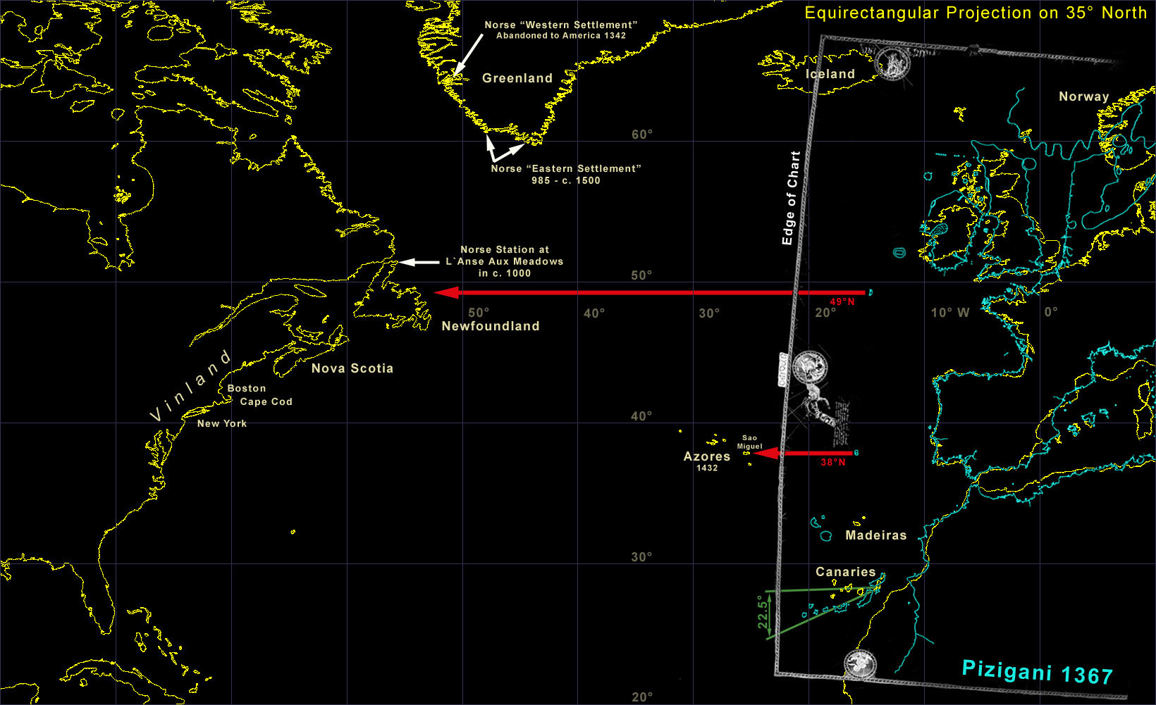
In the Atlantic the chart has the Madeiras and Canaries island archipelago at roughly the correct positions. In the west at about the latitude of the Azores there is an island named "insula de bracir". Cortesao suggested it to be Terceira, one of the larger islands at the center of the Azores group.
By correct rotation of the Atlantic chart portion to the equirectangular projection this island is with really good accuracy directly on the parallel of the main Azores island, Sao Miguel. Cortesao claimed that the Azores, the Madeiras and the Cape Verdes islands were depicted on charts a considerable time before their first mentions in the archival record.[51] Cortesao reported the first definite knowledge of the Azores by 1427, Hennig by 1432.
North of the possible Azores is another island at the latitude of Newfoundland. At Newfoundland was the European settlement site of L'Anse aux Meadows, discovered in 1960. According to C14 data it was occupied around 1000. According to several historical records the land "Vinland", somewhere south of Newfoundland, was discovered around this time. According to the records, Vinland was visited by Europeans for over 400 years.[52] The last known record that mentioned current Vinland voyages is a German one of 1434.[53]
So the chart may show the most eastern island of the American continent. It certainly shows the European latitude one would have to run for the shortest way to cross the Atlantic.
The questions seems valid why only Newfoundland was on the map and - except the Hercules or Antilia issue[54] - no hint of the American continent.
Most records of sailing voyages along the American east coast down to Florida[55] were in Norse language and at first probably in rune writings. This language barrier and the distance from Norway to Italy is the usual explanation why America was unknown in the south of Europe. But that is not correct. The German bishop Adam of Bremen reported the discovery of Vinland in a Latin book of 1072 about geographical and historical matters. Greenland, where the voyages started, had an operational bishop seat in Gardar since 1112 and the first bishop there even made a voyage to Vinland.[56]
It was the foremost duty of a bishop to report all important news to the the Vatican and therefore at least some in Italy were well informed on the new land in the west. The only explanation for the lack of public knowledge seems to be a strict secrecy order. The warning about voyages west of the "Azores" on this chart may well be due to such an order to deter any uninitiated casual reader or chart thief.
These islands (Newfoundland, Azores, Madeiras, Canaries) are the only islands in the Atlantic on the map. Only close to and around Ireland and Great Britain, additional real or fictional islands can be found. That is in strong contrast to some other alleged pre-discovery maps like the more famous "Zeno map" filled with islands. This significantly changes the statistical viewpoint in favor of the islands on the 1367 chart being real, not fictional.
But for the most controversial parts, the Azores and Newfoundland, even the latitude of the island position is correct. The Azores main island latitude is hit within a fraction of a degree. At Newfoundland the center of the island is hit. This all left no doubt that those "pre-discovery" islands are on the chart.
It seems inevitable to accept that the chart has Atlantic islands information that could not be from known Italian discoveries. Neither from Spanish nor Portuguese ones, because their age of discovery started later.
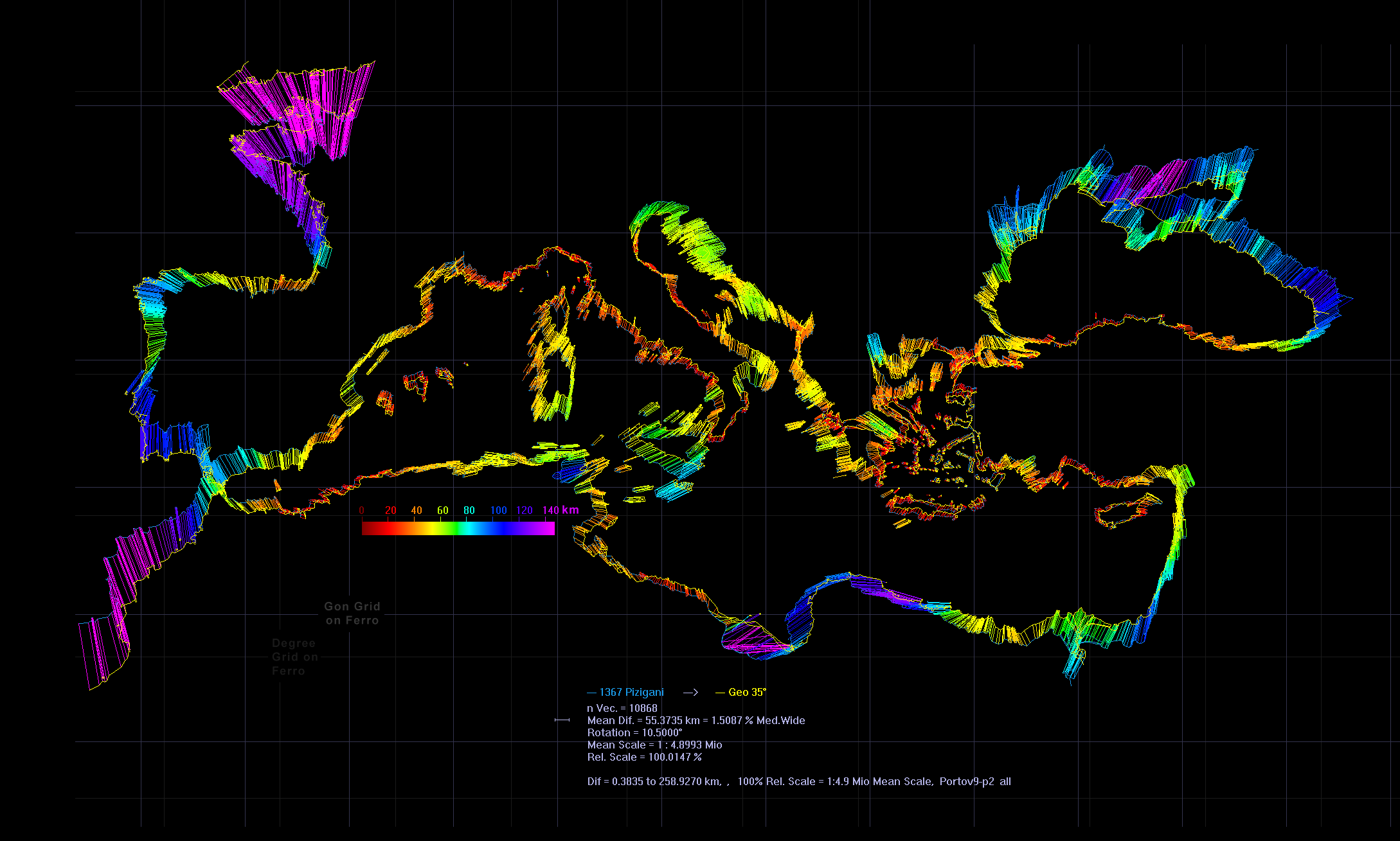
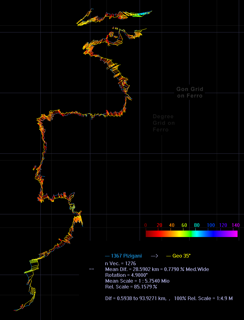
Based on Jomard, a cartometric analysis was done much like described for the Carte Pisane here. The coastline was corrected to a mathematically perfect rhumb net, vectorized and the 10868 vectors distorted to fit an equirectangular projection for 35° North. This type of projection was chosen for simplicity.
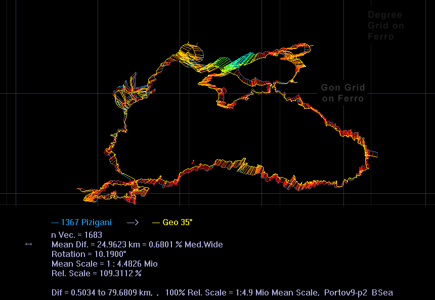
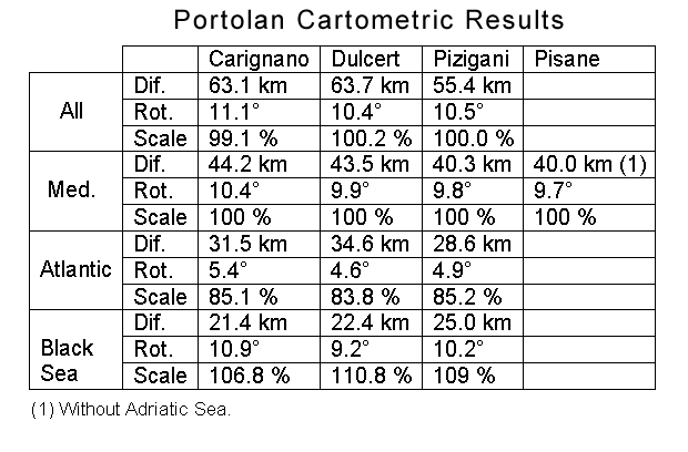
The overall match of the normal portolan area (Atlantic, Mediterranean, Black Sea) has a an average difference error (RMS) of +-55.4 km or 1.5 % the wide of the Mediterranean. In other words, if the portolan coastline is placed over a modern map, the gap between the lines is typically 55.4 km or 11.3 mm on the 1367 chart. The whole span of the analysed chart, from the African cape near the Canaries to the eastern Black Sea, is 5360 km and the 55.4 km are only 1.0 % of that span.The error difference along the coastline goes from 0.38 km to 259 km. The average rotation is 10.5°. The largest errors are in the Atlantic, Syrte and Black Sea. Except Africa southwest of Crete, the result is very typical for a portolan. For comparison, the Dulcert of 1339 has +-63.7 km and 10.4° rotation.
The Mediterranean basin had an error of 40.3 km (8.2 mm, 1.1 % total basin wide) and rotation of 9.8°. Dulcert had 43.5 km and 9.9°. The Black Sea alone had 25.0 km (5.6 mm), 10.2° rotation and about 109 % the scale of the Mediterranean basin. Dulcert had 22.4 km, 9.2° and 110.8 % scale. The Atlantic alone had 28.6 km, 4.9° rotation and 85.2 % scale of the Mediterranean. Dulcert had 34.6 km, 4.6° and 83.8 % scale. The Atlantic going from c. 26°N to 51°N (2780 km) is better than the Dulcert one, especially around southern England. It is with an average error of 4.9 mm of such a good fit that one may suppose the original projection not to be far away from the chosen one.That Atlantic and Black Sea on all portolans were of different scale than the Mediterranean was known at least since Wagner (1895) more than 100 years ago. If the Atlantic is corrected in scale and rotation to the Mediterranean it results in an average error of 38.67 km. Adding a corrected Black Sea results in an average error of the whole chart of 36.55 km. That is 7.5 mm on the one meter sized chart.
This whole chart goes from southwest England to the southeastern Mediterranean over 4000 km, of which the 36.55 km are only 0.9 %. From the African cape near the Canaries to the eastern Black Sea it is 5360 km and the 36.55 km are only 0.7 %. Compared to other early portolans this chart is the most accurate.
On an etalon analysis with the Pisane, see [history.html#Etalon_Analysis here.]
For a special analysis a detailed distortion grid was created. About the intentions and results see [history.html#Distortion_Grid here.]The equirectangular projection used here is free of any distortion along the 35° Northern parallel. Further north the east-west distances get dilated up to 26 % at the 44° N parallel near Marseille. To the south the east-west distances get compressed by up to 9 % at the 32° N parallel near Alexandria.
The cartometric analysis shows that the chart matches these distortions of the projection for the Mediterranean within 1.1 %. In other words, this distortion of c. +26 % to -9 % is already in the medieval chart.
There are several other possible projections with very similar distortions. So by this good match it is still not possible to decide that the now chosen projection was really the one the initial map was based on.
But it is absolutely certain that this portolan is based on a projection. It could not be compiled from "flat" planimetric maps. Otherwise the error had to be beyond 30 % and not as low as 1.1 %.[57]
The good accuracy on long ranges and the poor accuracy on short ones may be explainable by a bottleneck in the transmission history of the portolans: all portolans may have been enlarged copies from one single small map. Maybe this small map was found during the Middle Ages in a book from Roman times. This was first suggested by Grosjean.[58] It would explain the lack of latitude and longitude values too, because such data was of no use around 1200.
Such a bottleneck-like transmission map should leave very specific errors in portolans. Small islands would be initially not present. The lot of small islands, coastline details and harbor names of the portolans were then later medieval additions. These improvements could not have happened suddenly but by a gradual development. The oldest portolans should have errors here that the later ones no longer had. That is the case on this chart.
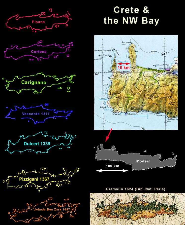
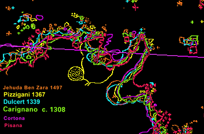
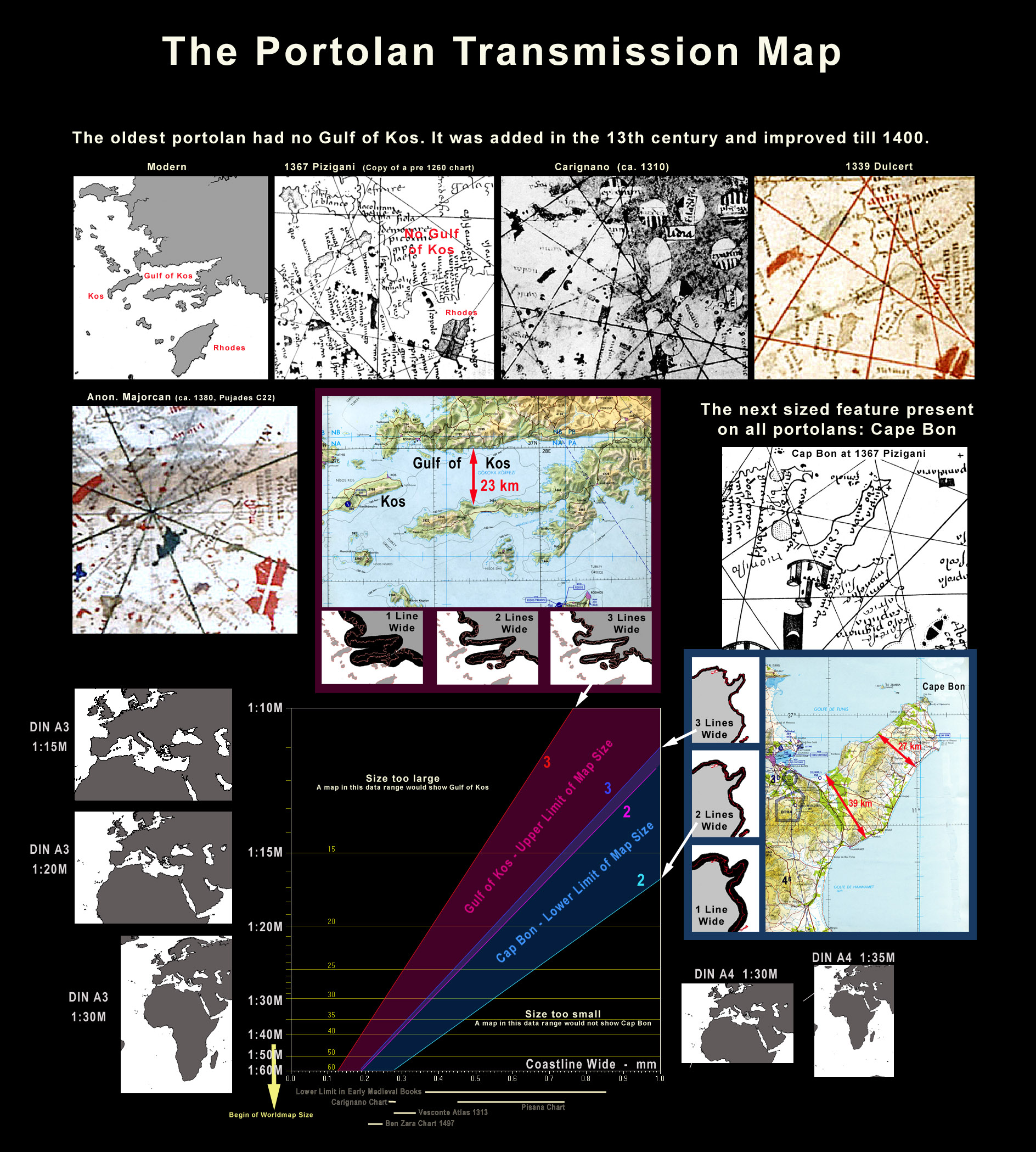
In the south-west corner of Turkey, opposite the island of Kos, is a deep gulf up to 23 km wide and 85 km deep inland. This chart is the only portolan that has no Gulf of Kos.[60] This missing Gulf is the largest feature missing on any Mediterranean portolan.
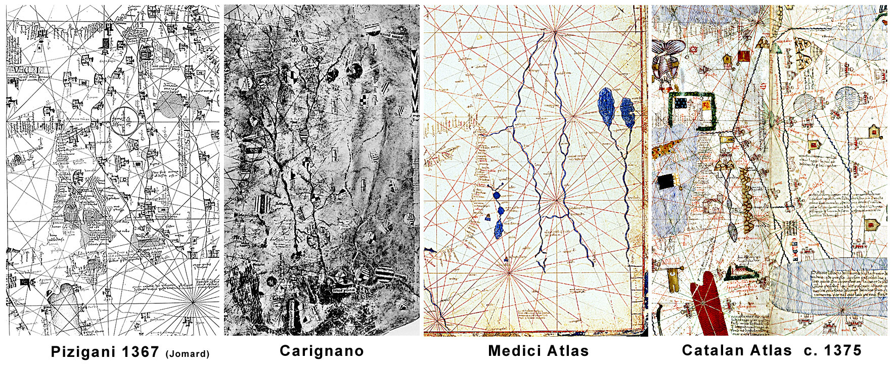
It seems the Gulf of Kos was one of the latest features added to the early portolans because we see it introduced in three different shapes. These three lines of tradition could be analysed up to mathematical accuracy. The first and probably oldest tradition (after the none Gulf) features a large upward sling on the Italian portolans of Carignano and Vesconte. From this a round bay evolved on Catalan type portolans like Dulcert, Atlas Catalan 1376 or the Medici Atlas 1351.[61]
The third shape tradition is the most accurate. It is a deep long Gulf and a good Kos island too. Amazingly it is only on the oldest extant portolans, the Carte Pisane and the Cortona. We probably see here the final results of a longer secret improvement effort by people aware of the origin and shortcomings of the portolans. The Cortona chart was a direct work copy of a now lost up-to-date improvement master map. The Pisane was probably an unauthorized compilation of an atlas version of this last version master map.
Some time after 1300 different development stages of this master map became the sources for the chart makers in Italy or the Catalans of Majorca. The Italians got an early version, the Catalans a later one but none got the last version. The earliest known master map version was the Pizigani 1367 chart.
If the Gulf is 1 line wide it could not be drawn. By 2 lines wide it could be drawn and by 3 lines wide it probably would be drawn. Cape Bon could be drawn only 1 line wide. But then the outline would not be as complicated as it is. So at least 2 lines or better 3 lines wide were necessary, too. On a diagram of scale versus ink line width we get an upper (red) and lower (blue) area for the size of the transmission map. There is some overlap around a line width of 10 km.[62]
By the 10 km value for the coast line width, the width of the ink line in mm directly determines the scale of the map.
A width of 0.5 mm would be fine for a medieval book letter but rather coarse for a portolan. But most of the somewhat amateurish drawn Carte Pisane used an even wider line. This 0.5 mm would result in a scale of 1 : 22 million. It would be the area of the normal portolan on one DIN A4 book size page. In that case the transmission map would probably be from the page of a medieval codex and present the area of the Roman Empire and the adjacent regions.
For an ink width of 0.28 mm like used by Carignano and Vesconte (1313), one gets a scale of 1 : 40 million. That is the size of a world map on a 1 meter wide chart. The lower professional limit[63] seems to be 0.21 mm from the portolan of Jehuda Ben Zara (1497). It would be a scale of 1 : 55 million and may represent a world map of 0.73 meters wide.
So this calculations suggests one shall look for evidence whether a world map was ever under discussion to be related to portolans or classical maps.

